With my teeth I tear open a bag of muesli. It’s early, very early. The bag gives in and opens up. “Maybe it’s too early”, I muse to myself. Helga crawls out of the rooftoptent, a sleeping bag tucked around her. We have a quick breakfast before packing everything up. Everything got wet because of the rain last night. When we went to bed the whole sky was clear and hundreds of stars shone bright. But the wind brought a vast amount of clouds above us while we were sleeping and unceremoniously dropped its contents. We woke and from the tent we could see lightning finding its way to the ground while thunder kept us from our sleep for a while.
We fold up the tent while it is still wet and put everything in its place. The sun manages to get through the clouds when we get in to our car and we head west.
—————————————————————————————————–
One of the largest national park in South Africa, Addo Elephant National Park has expanded to conserve a wide range of biodiversity, landscapes, fauna and flora. Stretching from the semi-arid karoo area in the north around Darlington Dam, over the rugged Zuurberg Mountains, through the Sundays River Valley and south to the coast between Sundays River mouth and Bushman’s river mouth, Addo covers about 180 000 hectares (444 700 acres) and includes the Bird and St Croix Island groups.
The original elephant section of the park was proclaimed in 1931, when only eleven elephants remained in the area. Today this finely-tuned ecosystem is sanctuary to over 600 elephant, lion, buffalo, black rhino, spotted hyena, leopard, a variety of antelope and zebra species, as well as the unique Addo flightless dung beetle, found almost exclusively in Addo. The park can exclusively claim to be the only national park in the world to conserve the “Big 7” – the Big 5 as well as the southern right whale and great white shark off the Algoa Bay coast.Plans are currently afoot to include the proposed proclamation of a 120 000 ha (296 500 acre) Marine Protected Area which includes islands that are home to the world’s largest breeding populations of Cape gannets and second largest breeding population of African penguins.
Light-yellow coloured sand tracks lead us through the park. The sun rises slowly into the sky while we drive along looking around us for wildlife. We’re in luck. We’re caught of guard by one closer than we expected. A leopard turtoise slowly, but confidently crosses our path while he chews on a green sapling which managed to grow through the sand on the track. We drive around it like a large rock in the savannah.
The sandy track leads us past something we came to see: We drive on while the big male elephant barely seems to notice us. The creases in his skin are noticeable, his ears are frayed and his trunk scans the ground, probably looking for water or food.
The next time we are eye to eye with an elephant is when we drive on a path with a lot of bushes on the sides. The whole way we try to look sideways and through the vegetation, but only the enormous piles of dung give the impression that animals live here. Every once in a while there are small clearings on the side of the road which we eagerly look in to. We both look into the fourth clearing or so when our gaze is being met. A male elephant, three meters from the road, partly hidden, turns his head to our car. I brake and we’re standing still immediately. I’m not so sure this was the best idea. His trunk is waving towards us and glides like a garden hose on the loose past our car. Our windows are open and we both hold our breath.
The moment is broken when an even larger male elephant comes towards us aiming for the one who was exploring our car with its trunk. He turns around quickly and we can feel the car move. He puts his heavy feet in front of one another and makes his way fast into the bushes again. The other elephant is not that interested in us. He walks straight up to us, looks into the car, turns around and walks in the opposite direction as we are heading.
I let my camera fall into my lap and feel the excitement through my body. What an experience!
We lean out of our windows while scanning the horizon hoping for the luck we had earlier. And luck we have! At the end of the day, we have seen:
Elephant, Buffalo, Lion, Red Hartebeest, Warthog, Common Duiker, Eland, Burchells Zebra, Kudu, Black backed Jackal, Cape Grysbok, Flightless Dungbeetle, Ostrich, Secretary Bird, Leopard Turtoise.
Hundreds of drops at the same time beat against our front window. The window wipers are busy keeping it clear. The road in front of us is barely visible. The heater is on and Helga is driving while I put my bear feet where the heat comes from. We’re following the coast like we have been doing for a while now. There is no conversation and we are both miles away in thought. In my mind I am far away from where I am now; home in the Netherlands where our friends live, careers are chased, jokes are told and fun nights in the pub take place without us.
We stop in Port Elizabeth. We find a hostel where we can camp in the front garden. We find our winter clothes, dress ourselves in warm layers and even get out our warm Australian Uggs from deep down in the car. We did not think we would be needing those here in Africa. It’s a good day to stay inside.
The wind has been blowing full strength and it seems that all the rainclouds have blown away.
A wooden gate serves as an entrance to a farm. We see a ladder that goes up in to a large tree and ends in a plateau. From this plateau you can see the sun set. We park our car amongst the horses, fold out the tent and get visits from different cats.
The farm is not an active farm. Surrounded by trees of which some of them are nearly 800 years old, it has developed into a hostel and runs on volunteers. We feel at home.
Here we meet Richard le Sueur. He is a travelminded South African who published a book about Winter in Africa. He doesn’t own a house, lives from his suitcase, usually travels on his motorcycle and is also a South African actor. He spends hours with us and our maps and full of advice we continue our travels.
Our aluminium ladder leads me down the rooftop tent. The ground is moist and two deep brown eyes follow me around. These eyes belong to a pitch black farmdog who belongs to the farm where we decided to camp. Even though it is only 7 am his tongue hangs far out of his mouth. I look for my running shorts, tighten my laces and start on a route that leads me through a giant rock formation to a spring. The dog turns out to know the way. For an hour he leads me over the best track, rocks and sometimes water.
Around midday we decide to start on the Baviaanskloof.
Baviaanskloof (Wikipedia)
The Baviaanskloof Wilderness Area lies approximately 120 km. West of Port Elizabeth in the Eastern Cape Province, South Africa and comprises of approximately 270 000 ha. of unspoiled, rugged mountainous terrain. Starting in the East at Komdomo, the road leads through the rugged beauty of the “Grootrivier” Gorge on its winding path through this pristine conservancy, all the way towards Willowmore in the West. A total distance of about 203 km. The area offers a wide range of eco-recreational opportunities as well as a unique wilderness experience!
Road Conditions: The road (R332) through the Baviaanskloof is a narrow, steep, gravel surfaced, winding road, through breathtaking mountainous terrain. The distance between Komdomo at the Eastern entrance, to Willowmore in the West, is approximately 203 km. The traveling time however, is 6 to 8 hours. Presently the stretch of road between Cambria and Geelhoutbos can only be accessed with a 4×4.
Our tire pressure, which we adjusted to the terrain, helps us on the uneven path that we follow, but it doesn’t do us any good against the low hanging branches scraping against the side of the car and windows. We’re both sitting straight up in our seats and try to follow the movements of the car. Like a compass used on ships we adjust to the angle of inclination. We are startled when a branch scrapes over our roof rack and makes a very loud noise. We push the car through a reedy passage and follow the stream of a shallow overgrown river to the other side where we hit the gravel again. Groups of baboons run away for this giant white car invading their habitat.
This road leads us up to a narrow pass andwhen we are halfway up we encounter a group of Landrover Defenders. We try to put our car as far off the road as we can to let them pass. We get strained, but friendly smiles before they drive out of sight.
I hadn’t realised how technical this drive would be, otherwise we would have left well before midday. I can feel the sweat trickle down my forehead while I try to steer the car over the best track.
Suddenly a rock hits the inside of the wheel. Immediately we can hear a high pitched whistling noise. We stop the car on a slope and I get underneath the car to assess the damage. A rock turns out to have hit the protective shield for the brake disc. The shield is now pushed against the brake disc which makes the noise. By using a large screwdriver I manage to create some space between the two.
We set up camp in the dark right after we get out of the Baviaanskloof at a place where they farm limes and tobacco next to having a camping site.
Wilderness, a small village on the coast. It almost feels like you are in Austria.
We find a good place to camp, high up in the hills, watching over the town. We stay a few days before we start our trip to the Cango Caves.
Cango Caves: (Wikipedia)
The Cango Caves are located in Precambrian limestones at the foothills of the Swartberg range near the town of Oudtshoorn, in the Western Cape Province of South Africa. The principal cave is one of the country’s finest, and best known, caves. Although the extensive system of tunnels and chambers go on for over four kilometres, only about a quarter of this is open to visitors, who may proceed into the cave only in groups supervised by a guide.
The caves were discovered in 1780 by a local farmer named Jacobus Van Zyl. The chamber he first was lowered down into is as long as a football field.
The cave’s first official guide is purported to have walked 29 hours to find the end of the caves in 1898. When there, he is said to have calculated that he was 25 km from the entrance, and 275 m underground; his route apparently followed an underground river. So far, they are finding more and more caves to support this story.
The wind screams outside our tent and we are on a dreary campsite. The wind seems to push away the dark clouds and morning dew and leaves us with a sunny morning. The rays of sunshine slowly start to heat and dry up everything around us. We can also feel it in our bodies as we heat up with the rest.
The Swartbergpass, (Wikipedia)
The Swartberg Pass runs through the Swartberg mountain range in the Western Cape province of South Africa.
The Swartberg is amongst the best exposed fold mountain chains in the world, and the pass slices through magnificently scenic geological formations. Much of the Swartberg is part of a UNESCO World Heritage Site.
The pass is especially famous due to the spectacular geology that is exposed at its Northern end. The contortions in the rock display astonishing anticlines and synclines, and the vivid coloration of the surrounding Quartzite is remarkable. At the Northern end of the pass seven-hundred-metre-high quartzite cliffs of the upper Table Mountain Group can be seen, and these are often tilted through 90 degrees . Arguably the most famous of all these cliff faces is the spectacular ‘Wall of Fire’.
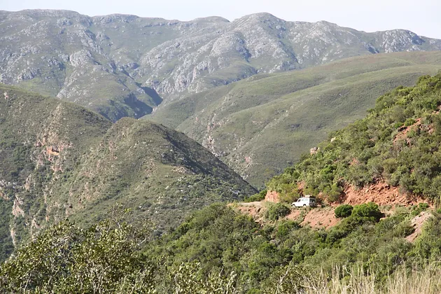
Loose yellow coloured gravel leads us up via a winding road. It almost looks like a snake. The road is a contrast to the mountain and is strengthened by a low stony wall on the side. The missing crash barrier gives us the opportunity to look down, deep down. Helga moves on her seat to the middle of the car while she leans a little bit to the left so she can just look outside. She’s been quiet for a while and she only lets me know she’s there by sighing every so often. When I look at my own hands I can see that my knuckles are white from holding the steering wheel too tight. I so would’ve preferred to drive this road with my motorbike, I think to myself. If we meet up with another car, there is going to be a serious challenge in passing each other….I follow the road as far as my eyes can see. The big cloud of dust behind us is clearly visible and when I look ahead the sky is clear.
A couple of signs on the road tell us that the pass is closed. We were warned about this by the owner of the campsite. He told us this is a way of stopping in transit traffic going to Prince Albert, since this is the fastest route. He told us to tell the workmen that we have a reservation in the area and that they would let us through.
Helga moves the sign on the middle of the road away and we drive past the first workers. They give us a look of slight disapproval while we pass the first machines. We drive all the way in to the shoulder of the road when a grader passes us with high speed. The two of us just fit on this road…
After a few kilometres we take a turn left and continue to Die Hell.
Die Hel is a narrow isolated valley about 20 miles long with a maximum of 600 feet wide located in the Swartberg mountain range.
The Gamkaskloof was discovered in the early 19th century by farmers, but the first permanent settler settled in the valley in the 1830s. It grow to a community of around 160 individuals. The residents lived there in comparative isolation for about 130 years. They used donkeys and walked across the Swartberg mountains to reach the nearest towns.
They farmed grain, vegetables, fruits, tea and tobacco, along with distilling witblits and brewing beer made from wild honey.
The only road in to the valley had not bin build until 1962 which led to the depopulation of the community. The children attended high schools in the nearby villages and most of them did not return to the subsistence life in the valley. The elderly retired to retirement villages outside the valley and the number of residents diminished until all but one person sold their homes to the Western Cape Nature Conservation Board in 1991.
Die Hel: Nobody is sure where the ‘Die Hel’ name came from. One popular story is that a Piet Botha (an animal inspector) visited the valley in the 1940s and used a particularly difficult route known as the ‘die leer’ into the valley. He described the experience as “hell”. Another story is that workers that worked at the farms where not allowed to leave once arrived in the vally. This valley is one of the most historical places in the world, still having many untold stories and surely a few secrets never to be known.
Up until today the drive to Die Hell stays a hell of a ride. A 46km one way route. Getting there is possible, but you need a 4WD and nerves of steel to navigate the snaking dirt road that offers the only access to Die Hel.
A small, winding strip almost looks like a divide. We try our best to stay on the track, but doing your best is not enough, looking into the enormous abyss we figure that a small mistake is all it takes…Rusty carwrecks deep down show us what remains of small mistakes.
At the end of the long and winding road we reach the highest point and before us the valley opens up. We descent and drive past the remains of some old farmhouses. Just before we reach the end of the gorge (kloof) we see a beautiful green lawn with firepits. It gives us the impression that we have reached the oasis in the desert. The owner is a friendly guy who gives us permission to camp.
As soon as it turns dark we really notice that we are all alone, the moon and stars are at their brightest. When we look around us we see a lot of glowing eyes out of the vegetation: baboons, badgers and frogs are hiding all around us.
We build a slackline in between two trees, we run and build a fire for a hot shower. Or rather, we try to do that last thing. Many places in South Africa where there is no permanent source of gas or electricity they use a donkey system. This is barrel made of (stainless) steel which is under pressure from a water pipe. Cold water from the water pipe comes in from underneath and hot water comes out of the top when you have a fire under the barrel.
It is already very dark outside when we wait by our campfire for the water to heat up so we can have our shower under the bright stars. Our wait comes to an end when we hear a pipe burst and we see a mixture of cold and hot water come from the ground while the barrel looses its pressure as does the water pipe itself. Like a little fountain the water leaps us from the ground. Helga runs to the nearest stream to get water to douse the fire under the barrel while I get the shovel to find the waterpipe. Just before Helga comes back with the water I can see the barrel shrinking due to the uneven distribution of heath and no water in the barrel. The plastic waterpipe is soon found and when I close the supply of water towards the donkey the pressure is back up. No shower for us though…
When we inform the owner of the campground what has happened we get a big smile: “Ah well,” he says, “I made the donkey myself and I was still testing it. It doesn’t really matter, I’ll either fix it or build a new one.” Enough time here in Hell.